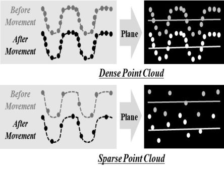
The group applies laser scanning technology as a displacement measurement technique for infrastructure. A three-dimensional point cloud can be collected by the laser scanning and allow for the analysis of displacements of the entire infrastructure. Laser scanning has a low accuracy in the range of millimeters, but the group is improving accuracy by CANUPO, a machine learning method, P2P-TA, etc. as well as via conventional point cloud analysis methods.


Selected references
- Seo H. (2015). Utilising laser scanning monitoring to evaluate the performance of slopes above a tunnel entrance., GE Slope Engineering and Geotechnical Asset Management 2015, London, UK. 18-19 November, 2015.
- Seo, H. J., Acikgoz, S., Zhao, Y. (2017). Monitoring of Retaining Wall at Tunnel Entrance using Three Dimensional Laser Scanning., The 2017 World Congress on Advances in Structural Engineering and Mechanics (ASEM17), Seoul, Korea, 28 Aug.-01 Sep, 2017.
- Seo, H.J., Zhao Y., Wang, J. (2019). Monitoring of Retaining Structures on an Open Excavation Site with 3D Laser Scanning. International Conference on Smart Infrastructure and Construction 2019 (ICSIC), 8the - 10th July, Cambridge, UK
- Seo, H. J. (2020), Monitoring of CFA Pile Test using Three Dimensional Laser Scanning and Distributed Fibre Optic Sensors, Optics and Lasers in Engineering, 130 (Online Published).
- Seo, H. J. (2020), Long-term Monitoring of zigzag-shaped retaining structure using laser scanning and analysis of influencing factors, Optics and Lasers in Engineering (Online Published).
Back to: School of Engineering